


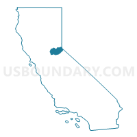
El Dorado County--El Dorado Hills PUMA, California
About
Outline

Summary
| Unique Area Identifier | 192199 |
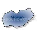
| Name | El Dorado County--El Dorado Hills PUMA |
| State | California |
| Area (square miles) | 1,786.36 |
| Land Area (square miles) | 1,707.88 |
| Water Area (square miles) | 78.47 |
| % of Land Area | 95.61 |
| % of Water Area | 4.39 |
| Latitude of the Internal Point | 38.78553200 |
| Longtitude of the Internal Point | -120.53439810 |
Maps

Graphs
Select a template below for downloading or customizing gragh for El Dorado County--El Dorado Hills PUMA, California


Neighbors
Neighoring Public Use Microdata Area (by Name) Neighboring Public Use Microdata Area on the Map
- Alpine, Amador, Calaveras, Inyo, Mariposa, Mono & Tuolumne Counties PUMA, CA
- Carson City, Lyon, Douglas & Storey Counties PUMA, NV
- Placer County (East/High Country Region)--Auburn & Colfax Cities PUMA, CA
- Sacramento County (Northeast)--Folsom City, Orangevale & Fair Oaks (East) PUMA, CA
- Sacramento County (South)--Galt, Isleton Cities & Delta Region PUMA, CA
Top 10 Neighboring County (by Population) Neighboring County on the Map
- Sacramento County, CA (1,418,788)
- Placer County, CA (348,432)
- El Dorado County, CA (181,058)
- Douglas County, NV (46,997)
- Amador County, CA (38,091)
- Alpine County, CA (1,175)
Top 10 Neighboring County Subdivision (by Population) Neighboring County Subdivision on the Map
- South El Dorado CCD, El Dorado County, CA (102,407)
- Rocklin CCD, Placer County, CA (85,223)
- Folsom CCD, Sacramento County, CA (72,163)
- Auburn CCD, Placer County, CA (44,468)
- North El Dorado CCD, El Dorado County, CA (31,207)
- South Lake Tahoe CCD, El Dorado County, CA (30,728)
- Placerville CCD, El Dorado County, CA (16,716)
- Lake Tahoe CCD, Placer County, CA (10,448)
- Pine Grove-Silver Lake CCD, Amador County, CA (9,604)
- Sutter Creek-Plymouth CCD, Amador County, CA (8,382)
Top 10 Neighboring Place (by Population) Neighboring Place on the Map
- Folsom city, CA (72,203)
- El Dorado Hills CDP, CA (42,108)
- South Lake Tahoe city, CA (21,403)
- Cameron Park CDP, CA (18,228)
- North Auburn CDP, CA (13,022)
- Diamond Springs CDP, CA (11,037)
- Placerville city, CA (10,389)
- Pollock Pines CDP, CA (6,871)
- Rancho Murieta CDP, CA (5,488)
- Shingle Springs CDP, CA (4,432)
Top 10 Neighboring Elementary School District (by Population) Neighboring Elementary School District on the Map
- Buckeye Union Elementary School District, CA (36,051)
- Rescue Union Elementary School District, CA (34,326)
- Auburn Union Elementary School District, CA (33,064)
- Eureka Union Elementary School District, CA (26,800)
- Loomis Union Elementary School District, CA (19,259)
- Mother Lode Union Elementary School District, CA (15,401)
- Placerville Union Elementary School District, CA (15,279)
- Pollock Pines Elementary School District, CA (8,777)
- Gold Oak Union Elementary School District, CA (8,334)
- Foresthill Union Elementary School District, CA (6,056)
Top 10 Neighboring Secondary School District (by Population) Neighboring Secondary School District on the Map
- Roseville Joint Union High School District, CA (161,902)
- El Dorado Union High School District, CA (136,722)
- Placer Union High School District, CA (85,905)
Top 10 Neighboring Unified School District (by Population) Neighboring Unified School District on the Map
- Elk Grove Unified School District, CA (313,989)
- Folsom-Cordova Unified School District, CA (122,238)
- Douglas County School District, NV (46,997)
- Amador County Unified School District, CA (38,091)
- Tahoe-Truckee Joint Unified School District, CA (31,699)
- Lake Tahoe Unified School District, CA (29,839)
- Black Oak Mine Unified School District, CA (13,572)
- Alpine County Unified School District, CA (1,175)
Top 10 Neighboring State Legislative District Lower Chamber (by Population) Neighboring State Legislative District Lower Chamber on the Map
- Assembly District 4, CA (536,793)
- Assembly District 10, CA (508,384)
- Assembly District 5, CA (498,085)
- Assembly District 39, NV (53,415)
Top 10 Neighboring State Legislative District Upper Chamber (by Population) Neighboring State Legislative District Upper Chamber on the Map
Top 10 Neighboring 111th Congressional District (by Population) Neighboring 111th Congressional District on the Map
- Congressional District 2, NV (836,562)
- Congressional District 3, CA (783,317)
- Congressional District 4, CA (774,261)
Top 10 Neighboring Census Tract (by Population) Neighboring Census Tract on the Map
- Census Tract 308.03, El Dorado County, CA (7,241)
- Census Tract 206.01, Placer County, CA (6,911)
- Census Tract 308.08, El Dorado County, CA (6,897)
- Census Tract 85.08, Sacramento County, CA (6,825)
- Census Tract 318, El Dorado County, CA (6,798)
- Census Tract 86, Sacramento County, CA (6,784)
- Census Tract 306.02, El Dorado County, CA (6,781)
- Census Tract 308.04, El Dorado County, CA (6,377)
- Census Tract 85.01, Sacramento County, CA (6,228)
- Census Tract 307.01, El Dorado County, CA (6,205)
Top 10 Neighboring 5-Digit ZIP Code Tabulation Area (by Population) Neighboring 5-Digit ZIP Code Tabulation Area on the Map
- 95630, CA (72,180)
- 95762, CA (38,797)
- 95667, CA (36,726)
- 96150, CA (29,792)
- 95682, CA (29,114)
- 95603, CA (27,844)
- 95726, CA (8,842)
- 95658, CA (6,285)
- 95683, CA (6,180)
- 95631, CA (6,076)